Welcome to
the Island of St. Martin & Sint Maarten in the Caribbean -
LukeTravels.com™
Main Page
 About the Island of St Martin - St. Maarten
 Around the Island
 The Beaches
 How to get to St. Martin - St. Maarten
 Map of the Island
 Airfare & Hotel Info
 Contact
Us
 Advertise
Here
 LukeTravels.com Home
Page
 Amsterdam - Holland
 Saba - Netherlands Antilles
 St. Barth - French West
Indies
 St. Martin / St. Maarten: Introduction
 According
to legend, Christopher Columbus discovered the island in 1493 on the feast day of St.
Martin of Tours. During the 140 years that followed, the Spanish, French and Dutch
disputed possession or at least the right to use the resources -- of St. Maarten/St.
Martin. In the 1620s, the Dutch first began to ply the island's ponds for salt, so
important to the herring industry back home.
St. Maarten / St. Martin is the smallest island in the world to be divided between two
sovereign powers. Its current boundary the result of numerous wars between the great
European powers in the 17th century.
Ownership of the island is split between the Dutch
and French, yet no rift exists between the peoples of these two cultures. In fact, the
island's inhabitants are proud of a near 350-year history of peaceful co-existence.
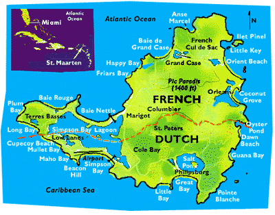
Despite the Dutch presence on the island, the Spaniards recaptured St. Maarten/St. Martin
in 1633 and one year later built a fort at Pointe Blanche to assert their claim. Eleven
years later Peter Stuyvesant, director of the Dutch West India Company based on Curaçao,
led an attack on the Spanish position on St. Maarten/St. Martin. After a month of futile
fighting, the Dutch retreated.
 St. Martin / St. Maarten:
Political Status
As a reward for successfully defending the island, the Spanish commander was granted his
request that he and his men be allowed to leave. Legend has it that five French and five
Dutch prisoners escaped and stayed behind. These Frenchmen and Dutchmen were the first of
their respective countrymen to share the island.
|
They contacted their home governments
through settlements on St. Eustatius and St. Kitts, bringing contingents from both
countries to St. Maarten/St. Martin. After a period of uneasiness with neither side really
gaining the military advantage, a truce was enjoined.
On March 23, 1648, a treaty was concluded atop Mount Concordia delineating the boundaries
of the island. The Dutch received 16 square miles and the French received 21 square miles,
owing to the latter's superior naval presence in the region when the treaty was signed.
|
|
|
The French and Dutch were not always as neighborly as they are today. The territory
underwent 16 changes of flag from 1648 to 1816, with France, Holland and even Britain
claiming it at times.
 St. Martin / St. Maarten:
History
The establishment of sugar cane plantations during the late
1700s inevitably brought slavery to the island. The exploitive Colonial system remained
intact and prospered so long as there were slaves. Once slavery was abolished (in 1848 on
the French side and in 1863 on the Dutch), however, the island's economy suffered greatly.
St. Maarten/St. Martin became mired in a depression that lasted until 1939, when all
import and export taxes were rescinded and the island became a free port.
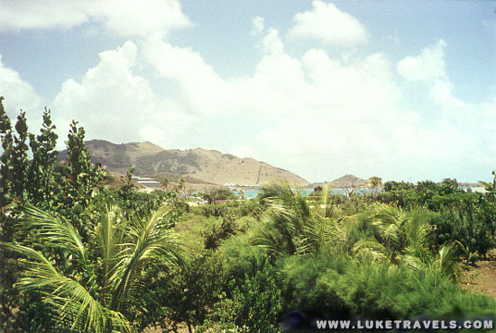
Photo
Copyright ©
LukeTravels.com - Luke Handzlik - All Rights Reserved
Orient Beach Area
Thereafter, the island developed as a Caribbean trade hub. The most dramatic advances came
in the 1950s, made possible by Princess Juliana International Airport's opening 10 years
earlier. The next few decades saw the development of many large-scale properties and
casinos on the Dutch side of the island. The French side began developing rapidly in the
1980s with the passage of a tax law known as de-fiscalization.
As tourism flourished on St. Maarten/ St. Martin, the island's airport
became one of the busiest in the region. It now serves as a hub for
flights to several neighboring islands. In addition, more cruise ships
began to visit, adding to the island's prosperity.
|
The arrival of Hurricane Luis on the evening of September 4, 1995, was a defining moment
in the recent history of St. Maarten/St. Martin.
As the storm abated in the early morning hours of September 6, the
shell-shocked islanders emerged from their shelters to face scenes of
utter devastation.
A large proportion of houses had been demolished or lost their roofs;
many popular tourist resorts had suffered extensive damage. |
|
 |
Some 95% of the
boats around the island had been sunk or run aground; and every scrap of vegetation on the
island was stripped away, leaving a barren landscape.
Less than a month later, however, a few green shoots appeared among the seemingly lifeless
branches, and within a few days the entire island was blanketed in the emerald hues of new
growth. It was a sign of promise for a bright future. After Hurricane Luis, island
residents worked tirelessly in the rebuilding effort, and the results are remarkable.
Today there are few if any visible reminders of the historic hurricane, and the island's
appeal as a vacation destination is stronger than ever.
 St. Martin / St.
Maarten: About the Island
Sint Maarten, the Dutch
side, is known for its festive nightlife, fun beaches, and plentiful
casinos, while Saint Martin, the French side, is known more for its
world-famous nude beaches, jewelry and clothes shopping, exotic drinks
made with native rum-based guavaberry liquors, and rich French
Caribbean cuisine.
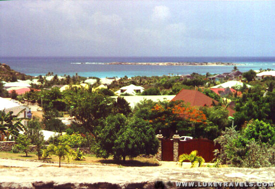
Photo
Copyright ©
LukeTravels.com - Luke Handzlik - All Rights Reserved
Orient Beach Area
 St. Martin / St.
Maarten: The Infamous Airport
The island is served by many major airlines that bring in large jets,
including Boeing 747s and Airbus A340s, carrying tourists from across
the world on a daily basis. This fuels the island's largest revenue
source, tourism. Princess Juliana International Airport -- which
opened a major new terminal in November, 2006 -- is famous for its
short landing strip —only 2,130 meters or 7,000 ft, which is barely
enough for heavy jets.
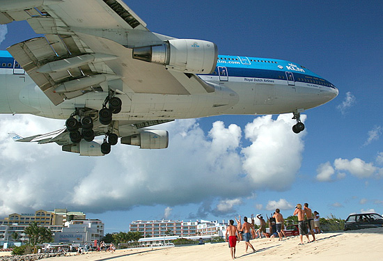
Because of this, the planes approach the island
flying extremely low, right over the beach (see photos below). Countless photos of large
jets flying at 10–20 m/30-60 ft over relaxing tourists at the beach
have been dismissed as "photoshopped" many times, but are nevertheless
real.
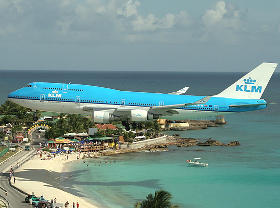
Photo
Copyright ©
C. Starnes
KLM Boeing 747-400 on its final approach into Princess Juliana Airport. At
Maho Beach
Princess Juliana International Airport (PJIA)
is the airport of St. Maarten. It is located 15 kilometers northwest of
Philipsburg and is operated by Princess Juliana International Operating
Company NV (PJIAE), a limited liability company, which is wholly owned by
PJIA Holding N.V. which in turn is fully owned by the Island Government of
the Island Territory of St. Maarten. Under a concession granted to PJIAE
by Government for a period of twenty years - effective January 3, 1997-
PJIAE manages, operates, maintains and develops the Princess Juliana
International Airport.
Photo
Copyright ©
europics
Amsterdam-originating KLM B747-400 on its approach into Princess
Juliana Airport.
PJIAE started as a small military base that was built in 1942, and was
converted into a civilian airport in 1943, the first in this part of
the Caribbean. It has played an important role in the socio-economic
transition of St. Maarten, from an agriculturally based economy into
one of the major tourist destinations in the Caribbean.
Today PJIA is the second busiest airport in the North Eastern
Caribbean, in terms of aircraft movements, behind San Juan, Puerto
Rico. PJIA is the single most important strategic asset of St.
Maarten.²
 St. Martin / St.
Maarten: Accommodations and More
Sint Maarten/Saint-Martin is home to several world-class accommodations,
including hotels, villas, and timeshares, many of which are privately
available for rent or sale. Some properties have over 200 rooms, while
others have fewer than twenty. Many are located directly on beaches and in
upscale shopping districts. Villas pepper the coast, boasting private
beaches. Some are private residences, while others are available to
affluent renters.
Rental cars are the primary mode of transportation for visitors staying on
island. The island is served by several well-known agencies. If any
driving is expected off the major roads (such as to some of the more
secluded beaches), a 4-wheel drive is recommended. Traffic on the island,
however, has become a major problem; long traffic jams between Marigot,
Philipsburg and the airport are common.
Because the island is located along the inter tropical convergence zone,
it is occasionally menaced by tropical storm activity in the late summer
and early fall.
Hurricane season is June 1 to November 30. If you're traveling during
hurricane season, it is important to monitor local weather information
during this time.
The island is widely known for its hundreds of gourmet (and more
moderately priced) restaurants on both sides of the island. |
|
|
Neighboring islands include Saint-Barthélemy (French), Anguilla (British),
Saba (Dutch), Sint Eustatius "Statia" (Dutch), Saint Kitts and Nevis
(Independent, formerly British). With the exception of Nevis, all of these
islands are easily visible on a clear day from St. Maarten.


